Over the first weekend in June, we visited Northern Ireland with Elwyn, Silvana and Priscilla's cousin, Sylvia. Our journey began in Belfast, but even in crossing the border the change was immediately apparent - and not just in the fact that kilometres turned to miles, or that the Gaelic promptly fell off town and street names. Rather it was in the proliferation of union jacks on display. Almost from every telegraph pole. From every street corner, and adorning many houses. Bunting aplenty. Doubtless this has always been the case in particular parts of the North, but in recent times there has been a particular intensity to the flying of the flag, prompted in no small part by the decision late last year to limit the number of days that the Union Jack could fly from the Belfast City Hall. And some have the myopia to say that symbols and national flags and emblems are but surface level fidgeting in politics these days. Not in this country. Scratch an Irish post office box, particularly one embossed with VR or GR (rarer), and you are likely to find dusty red paint from the pre-independence days underneath.
There is almost a determination, then, in parts of Northern Ireland, to display their Britishness in a more ostentatious way than perhaps in Britain itself. But one senses that it is an embattled Britishness, which on the 15th anniversary of the Good Friday agreement (signed in 1998) senses yet again that Britain itself may not be as interested in the North as the North would like it to be. Upon arrival we walked around the central business district of the city and looked at the impressive City Hall, replete with statue of Queen Victoria out the front, and, to the side of the building, a monument to the lost of the Titanic. Belfast, once a major shipbuilding hub, has long lost its industrial power and now the Titanic quarter is a major attraction for tourists. We will visit it later in the year.
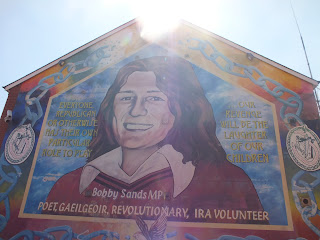
Below are some of the murals from the Protestant side - Shankill Road

We also saw the so called 'peace wall' which still separates the catholic and protestant areas - amazing that in this day and age this sort of structure can still exist, but of course the West Bank is another example. It is about three times the height of the Berlin wall and while the new shared government at Stormont (the Northern Ireland Assembly) wants to remove these walls in the next decade, our taxi driver said that both communities wanted them to remain - it made them feel safe. The backyards of houses along this wall are completely caged - to guard against objects thrown from the other side. The girls signed the peace wall, as all visitors are allowed to do so. It was on leaving the Catholic area that our taxi was waterbombed - myself and Elwyn seemed to bear the brunt of it. A bit of a fright when it happened. Relief when it was only water!!
From Belfast we moved on Carrickfergus where we stayed the night. The next morning, we headed up the Antrim coast which was truly a stunning drive. It's no wonder this is a major tourist attraction and thankfully we did not have to compete with too many buses. Our destination, ultimately, was the Giant's Causeway. But along the way we stopped at the Carrick-A-Rede ropebridge, which affords a stunning view of the northern irish coastline. The bridge was originally rigged and used by salmon fishermen and many of those fishermen crossed it in a much more daring manner than you do today! The bridge sways about 30m above the rocks and the sea. Both Pia and Ella initially refused to traverse it, however with some gentle persuasion undertook the perilous crossing. Both made it there, and back, and we are pleased to say!!
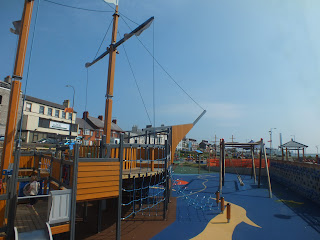
The castle at Carrickfergus and the fantastic playground there below - this was the highlight of Pia and Ella's trip!
Some of the stunning scenery along the Causeway Coastal Drive
Enjoying our trip with cousin Sylvia!
The lovely little village of Cushenden
Arriving at the Carrick-a-rede rope bridge - such stunning views

Next, the Giant's causeway, a UNESCO world heritage site that is every bit as impressive as it is made out to be. For all its antiquity, it's appearance is dramatically modernist: the pillars that strike out from the coastline reminded Priscilla and I of the Manhattan skyline, or, to early devotees of Superman, the planet Crypton. The Giant's Causeway is composed of countless hexagonal basalt columns and is the most popular site in the North. When John F Kennedy visited Ireland in June 1963, the Northern Irish PM, Captain Terence O'Neill, pleaded with the President to come and open the national park here, even asking British PM Macmillan to pressure Kennedy to do so. But Kennedy refused, fearing that such an event would involve him in the tricky terrain of the partition question. He went to Arbour Hill, gravesite of the 1916 leaders, instead, in Dublin.
Of course the legend has it that this feature was the handiwork of giants - specifically (Fionn mac Cumhail - pronounced Finn McCool!!) - and the tourist material and audio guide naturally play up this theme. Some believe it was the beginning of giant stepping stones to Scotland, only 60 miles off the coast at this point. More seriously, it is believed that the causeway was formed around 60 million years ago, when a thick layer of molten basaltic lava flowed along a valley in the existing chalk beds. According to the guide, the lava flow then cooled and hardened, and then contracted, creating a pattern of hexagonal cracks at right angles to the cooling surfaces. There is a much more detailed scientific explanation of what happened next, which I will spare you here because I do not quite understand it, however, it is an impressive sight, and perhaps one of the few world heritage sites you can walk all over.
Loving the red phone box here - you can tell we are in the UK!
The ruins of Dunluce Castle, just near the Giant's Causeway.
The view from our hotel at Portrush - overlooking Curran Strand!
Next post - Finishing the trip in Derry / Londonderry


No comments:
Post a Comment